
Canary in the Coal Mine: How One Small Island Became the Face of Bermuda’s Changing Climate
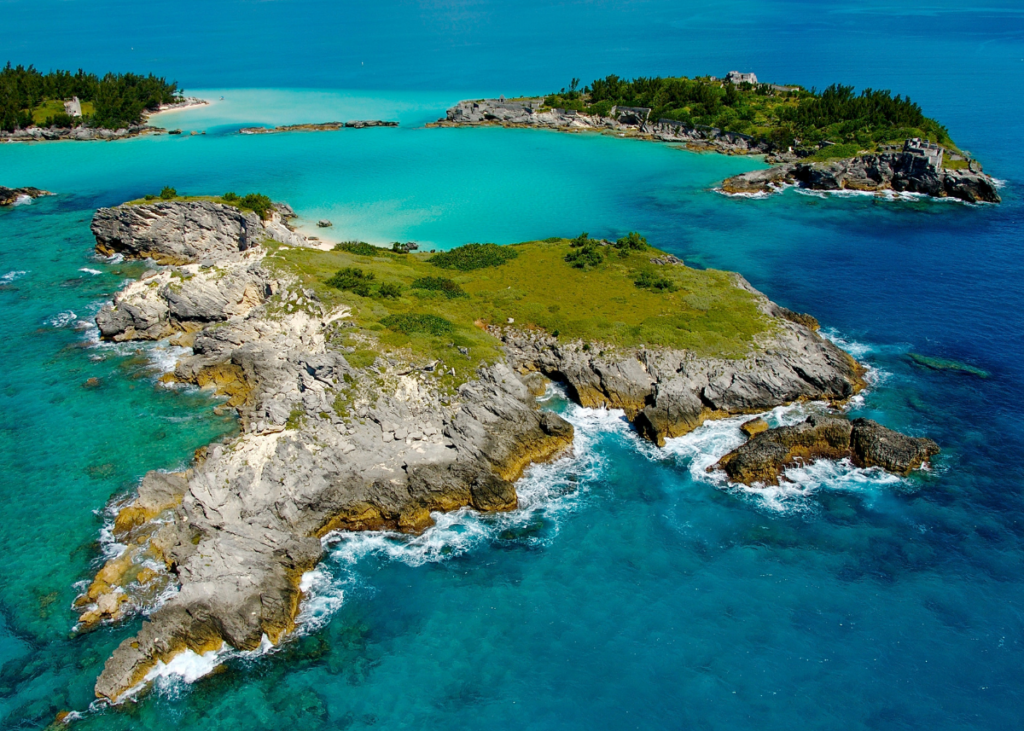
Charles Island. Photo by Gavin Howarth
Originally published January 15 in The Bermudian
By Jonathan Kent
Charles Island is one of a group of small, uninhabited islands that form a broken chain across the southern side of Castle Harbour. At least, for now it is one island — pretty soon it is likely to be two.
The pummelling it has taken from storm-powered waves has in recent years carved a trench through the island that has changed its centuries-old landscape. Could Charles Island be the “canary in the coal mine” of what is to come for Bermuda as a whole?
Chris Flook, a Bermuda naturalist and the small boats and docks manager at the Bermuda Institute of Ocean Sciences (BIOS), is highly aware of Bermuda’s physical vulnerability as a geographically isolated island in the high seas and says climate change is only exacerbating the threat of erosion. Few people are more familiar with local waters than Flook. His experience includes 16 years collecting marine specimens for the Bermuda Aquarium, Museum and Zoo; instigating the Bermuda Lionfish Project to control the destructive invasive species; and working as a consultant for the Pew Environment Group where he served as director of Blue Halo, an initiative to create a “no-take” marine reserve in the most environmentally sensitive areas of the Sargasso Sea. “Bermuda is an extinct volcano with a limestone cap on top,” Flook explains. Formed more than 30 million years ago, the volcano is thought to have once loomed more than 1,000 feet above sea level. Over the millennia, it has been worn down, as the water level rose and fell. Humanity has been a relatively recent arrival in Bermuda — “the last frame in a 24-hour movie,” as Flook puts it.
As a youngster growing up in the east end, the hump of Charles Island was a familiar shape to Flook. The brutal reshaping of the island by the elements has accelerated in recent years. “I went out to Charles Island to see how much more it had eroded after Hurricane Lee,” Flook says. “It’s not two islands yet, but it won’t be long.” Many islanders have seen other parts of the south shore change shape and features disappear as waves from storms smash into the limestone shoreline and shift sands. Expect more of this, he warns. “Bermuda has stopped growing and is getting smaller,” Flook says. “The sea level is rising and we seem to be getting stronger and more frequent storms. Climate change is also making the ocean more acidic, which means it dissolves the limestone more quickly. Eventually we will be like the legendary Atlantis, dissolving into the ocean.”

While, all being well, no one around today will be alive to see Bermuda disappear, Flook says he has witnessed an acceleration in the pace of change in recent years. The huge waves we can see during storms tell only a small part of the story — the true force of the ocean is the swell below the surface. “When you think that one cubic metre of water weighs one tonne, and you see the size of the rollers coming in during a storm, the island takes a massive pounding,” Flook says. “There is also churned-up sand that makes it into a heavier and denser slurry.” Flook recalls a coral study that involved 10-inch nails that had been driven into a reef. After a storm the nails were bent over at a 90-degree angle. The power of the ocean was also at work in the appearance of the “new rock” that many people noticed protruding from the ocean off Elbow Beach earlier this year. Flook checked it out and found that it was a massive boiler reef that had been tipped over, probably by storm-driven ocean swell. “The forces needed to do that are incredible,” he says.
Through his own day-to-day observations during a life on the water, Flook has seen many signs that the sea level is rising incrementally over time. Longer-term empirical evidence was unveiled by Philippe Max Rouja, Bermuda’s Custodian of Historical Wrecks, while he was looking at nineteenth-century photographs of Dockyard during a research project. As Flook describes, Rouja spotted that the waterline visible in the image, on a wall made of 12-inch blocks, was a full block lower in the pictures than it is today. Both Rouja and Flook were interviewed for a Bermuda-focused episode of Changing Seas, a South Florida PBS television series. Rouja warned that while the projected rate of sea level rise may seem slow-moving, complacency over increased impact from storm surges could be dangerous. “Rising seas aren’t just about averages — they’re about extents,” Rouja told PBS. “Changes at a local level may come far, far sooner than you might anticipate from what we project out for into the future with the averages.” It follows that the island should be adapting for scenarios like hurricanes hitting the island during high tide.
In this respect, Bermuda was somewhat fortunate with two of the most powerful hurricanes to hit the island in recent years, Gonzalo in 2014 and Nicole in 2016. In both cases peak surge coincided with low tide, according to Climate Change and Bermuda, Part I, a report by Dr Mark Guishard. The report noted: “The timing of the closest passage of Nicole, and its consequent peak surge, allowed Bermuda to avoid the worst storm tide impacts. If the peak surge had been six hours earlier or later, Bermuda would have experienced approximately 4.6 feet of water above mean sea level. The worst-case scenario would be for the peak storm surge associated with a hurricane’s closest point of approach to coincide with a high tide, during a period when a warm eddy is inflating the background water level above the normal tide.” Flook says that as the impact of extreme surges becomes clear over time, insurers will inevitably charge more to insure vulnerable oceanfront properties and may decide that some are uninsurable.
Sand shift is another feature of storm impact that many Bermudians have witnessed, particularly when a beach shrinks in the wake of a storm before gradually returning to its former state. The extent of sediment movement was captured in imagery from NASA’s Landsat satellite after Hurricane Gonzalo in 2014. Sand was dispersed up to 20 miles from the island. Rouja told Changing Seas about such sand-shift effects on one of the shipwrecks he monitors, the Marie Celestia, which sank in 1864. After huge storms such as Hurricane Fabian in 2003, part of the stern became visible as sands shifted, but only for about three days. “Now that part of the stern is visible all the time, so that says to us is that sand has not returned,” Rouja said.
Bermuda’s reefs are our defence against wave erosion, barriers that substantially dissipate the power of storm-generated waves and swell. “The reef system and the breakers are literally what keep us from disappearing,” Flook says. But the rise in ocean temperature, in addition to pollution, is harming the health of the reefs. At BIOS, researchers are testing different types of corals to measure their resilience against heat wave events. They hope to discover whether corals can build resilience through a “memory” of a bleaching event and whether such resilience can be passed on to the next generation of coral larvae. Their work in helping to build up the health of the reefs and strengthen the barrier they provide to stand up to changing environmental conditions will be critical for Bermuda’s future resilience. Charles Island is a graphic warning of the challenges we face.